Monday, October 6, 2014

2750 Gosworth Road, Victoria, BC


After coming across the link to the Google Maps street view of this house, I was curious about its current state, since the street view photo is from three years ago. So I biked by today, and instead of a house, there's just an empty lot. Since eventually Google will update their photos, I wanted to post some screenshots from the current street view so that there's still some record of the house out there. Couldn't find anything about it online, sadly, although I may have the wrong address since I'm just going by Google. 

ETA 5/30/15: So I just found out that Google keeps their old street view images available, and you see them easily--just click the little clock next to the date when you're in street view mode. Since I published this post they've updated the street view pics to May 2014 (when I first posted, the current ones were from September 2011), but you can go back and see both the 2011 images (found in this post) and ones from 2009--super fascinating to me, because the house was in way better shape then, so it's cool to see what it looked like before this. Anyway, I'll leave this post up, and might still do posts about lost buildings occasionally, even if Google does have its own record of them.

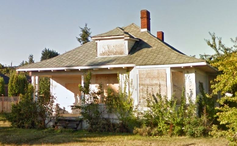
ETA 8/5/15: Finally got around to adding a screenshot from 2009's Google Maps to this post--see below! I also found out some actual information on the house. I had the address wrong originally (2759 instead of 2750), which probably didn't help.


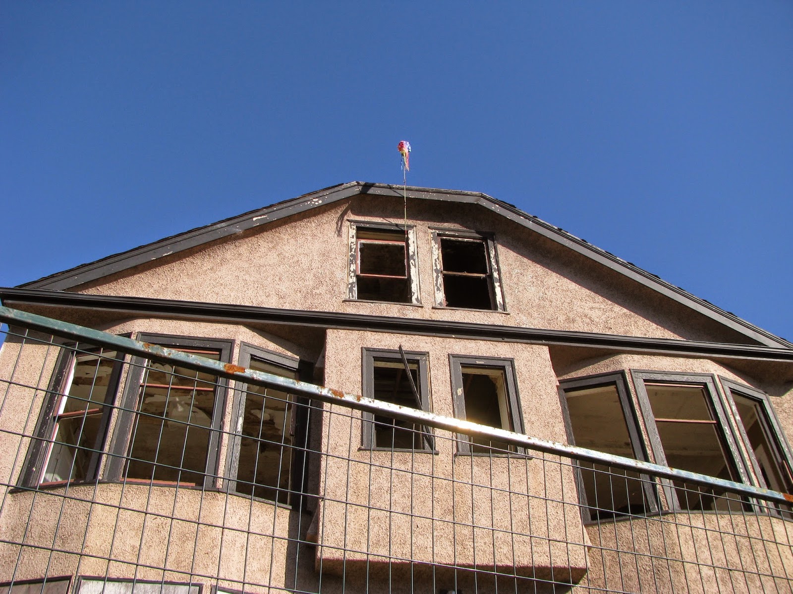
Anyway, according to this Facebook discussion, what went wrong was that "The owner attempted to lift the house to put in a basement. Basically he and a bunch of helpers began to jack it higher windows began to blow out and the house became unsafe. Friends live next door and watched and listened as the house was twisted apart."

Other people (in that discussion and another) were saying what a nice old house it was: "The fireplace had two faces in the two main adjacent entertaining rooms and [was] covered in an awesome royal blue tile which looked original with intricate metal work. It had side pillars denoting the dining area from the front lounge. The stairwell was quite grand. Farmhouse kitchen. And a tree growing partially inside the bathroom from the neglect." Someone who lived there in the 80s said it wasn't in the best shape even then. 

Here's a photo from January 2008, with a little more info in the comments. All I have otherwise is that a Mrs. P McGill lived there in 1917--so obviously it was built before then.

Below, the rest of the 2011 screenshots from the original version of this post.


in context
left side
front again
right side
better view of the right side
back

Sunday, October 5, 2014

Goodyear Water Tower, Williamsville, NY

This place isn't technically abandoned since it's obviously maintained and I believe still in use, but it is an interesting/unusual structure that I've visited, and the area around it is abandoned, so it's getting posted.


According to this pamphlet on Amherst, NY's historic properties (which is the only website I can find that mentions it, besides Town of Amherst board meeting minutes), it was built between 1915 and 1925 as part of the Josephine Goodyear Convalescent Home campus. The pamphlet notes that it was also used as a fire watch tower, and that it's the only known octagon-shaped water tower in Erie County (I like how they acknowledge that there could be other octagonal water towers in the county that they're just not aware of).

I found the pamphlet online while looking up other historic buildings in the area and was intrigued. After locating the tower on Google Maps I planned to visit it sometime if I could (especially after seeing it from Sheridan Drive while passing by once, which made it seem like it would be easy to get to), but didn't actually make it there until a week or so before I left the area. I found that you can't actually get to it off Sheridan but have to go into the little development on Hampton Hill Drive. It was weird parking on the street by a cluster of identical houses and striding off into what felt like their backyards. It was also weird seeing this white tower rising up above them.


view from Google Maps
There was a "Town of Amherst - No Trespassing" signs nearby, but it was by a road leading into the area rather than right by the tower, and there was no fence or anything to stop people from walking over to the tower, so I wasn't too concerned.

See how close it is to the houses?
There was a sign by the tower about video surveillance, but that didn't scare me too much.


As for the rest of the area, maybe it's just what's left of the convalescent home, since this site says it was sold after World War II. I couldn't find anything about who it was sold to or what was done with the area after that, but I did find this newspaper from 1936 with a cute article about Christmas for the kids in the home.


The person in the distance is my mom, who came with me.


There was a small network of roads and parking lots. Here's the area from above on Google Maps.


And some more evidence of its abandoned state.


After we left we found that we could see it from the parking lot of an office building on Main Street.


It's a simple but unique little building, something pretty to look at in contrast to the development and all the nearby office buildings.


Tuesday, September 30, 2014

City Methodist Church, Gary, IN

I drove through Gary, IN on my cross-continent move from Buffalo, NY to Victoria, BC and didn't get to spend nearly as much time there as I would have liked to. But I was there long enough to see that, as I'd read, it really is a half-ghost town. 


From Wikipedia: Gary "was founded in 1906 by the United States Steel Corporation as the home for its new plant," but "in the 1960s, like many other American urban centers reliant on one particular industry, Gary entered a spiral of decline [...] brought on by the growing overseas competitiveness in the steel industry, which had caused U.S. Steel to lay off many workers from the Gary area. [...] Owing to white flight, economic distress, and skyrocketing crime, many middle-class and affluent residents moved to other cities in the metro area such as Chicago." The population is now around 80,000, and "as of 2013, the Gary Department of Redevelopment has estimated that one-third of all homes in the city are unoccupied and/or abandoned."

And it's not just homes; this massive church has been empty and unused for almost 40 years.


I stopped by this one specifically after seeing it mentioned online. If you're interested, here's an article detailing its whole history; the article also has a lot of photos, past and present. It sounds like the building was in okay shape until a 1997 fire, which destroyed part of the roof.

When I was there (August of this year) you could walk right in, no fences or boards on the doorway, and I would have loved to explore it, but since I didn't have the time (plus it was kind of creepy), I contented myself with just walking in a little way.


And it's actually a good thing I didn't spend too long or go in any farther, because this website (which also has an awesome virtual tour) says you need a permit from the city to explore and photograph abandoned buildings. Luckily I didn't get in trouble for any of the photos I took.


This sign was outside, but I'm not sure why since it's got the wrong name...


At one point the city had plans to turn part of the building into a ruins garden, which would have been awesome, but there wasn't enough funding. It does get used, though, by photographers and also in movies (including, recently, Transformers 3), so unlike abandoned buildings that just get boarded up and left to rot, it is still serving a purpose. 

Sunday, September 28, 2014

2321 Cook Street, Victoria, BC


I noticed this place while driving by recently, and today I biked there to get a closer look and take a few photos.


Googling the address revealed that it had much more of a story than I expected. It was built in 1913 and used to be the Caldwell Apartments, where a murderer lived; he killed someone over a drug debt in 2005 and turned himself in a few days later, after police seized evidence against him in a raid on the house. Shortly after that the building's residents were ordered evicted, although it wasn't fenced or fully boarded up until 2013. This is the Google street view photo, which was taken in June 2012. 


Before that, and possibly after too, squatters lived there, although in June of this year there was a fire (photo at the link, and several more here) which left the building structurally unsound. Because of that, it's impossible for it to be inspected to determine the cause of the fire. Here's a photo I took of the right side, where the fire damage is more obvious.


And a photo from the Times Colonist:


VKA-2321COOK03457.jpg
source
It's a shame that it wasn't sold, fixed up, and put to use again before it was too late.
_____________________
Edit on December 9, 2014: Walked by today and the top back half is gone. According to this article it's finally being demolished, although they say demolition was scheduled to be completed by December 5th, which obviously hasn't happened. No one was working on it today at all, although the backhoe from the article's photograph was sitting in the driveway next door. Didn't get any pictures, but I'll have to go back and take a few before it's completely gone.
_____________________
Edit on May 16, 2015: Quite late, but I'm finally adding the photos of it half-torn down, which I took on December 12, 2014. 


this little boarded-up cabin in back is intriguing... not sure if it got torn down too or not
Next time I drove by it was completely gone. Today I found this photo from the 1970s (and was super excited), which would have been cool before but is even more meaningful now that the building no longer exists.


Found here.  You can see the little cabin in the background!
Also, a bunch more links which I apparently missed before:

Can't find anything about the future of the site. I'll have to bike by again sometime soon and see what it looks like now.

Saturday, September 27, 2014

Prudhommes Landing Inn, Ontario

Seeing this place was probably one of the highlights of the ill-fated trip to Toronto that my husband, a friend, and I took about two months ago. Road closures, high prices, a parking ticket, and bad traffic all made the trip more of an unpleasant than pleasant experience, which was unfortunate because I'd been looking forward to visiting Toronto for a long time. But while we were still on our way, blissfully unaware of how many hours we would spend sitting in an unmoving car or how much money two days in the city would cost us, we stopped for a bathroom break at a Tim Hortons near St. Catherines, Ontario. And to the right of the Tim Hortons just happened to be this place. 


I was super excited because I love abandoned buildings but had never actually gotten to look at one up close before (one that hadn't completely fallen apart, that is). So while my husband and friend were in Tim Hortons, I walked over and did what exploration I could in the short time that I had, which consisted of walking partway down the building and peering in each window I passed.


Here's how the pool room used to look:

photo from TripAdvisor.com

When I Googled it later, I found that there actually used to be an amusement park behind the hotel (if only I'd known when I'd been there; I would have loved to explore what remains of that, even though from what I read online there isn't much at this point). The hotel only closed a few years ago, I believe, but the amusement park--Wet and Wild--had been closed for a while before that. The comments on this article and this one are interesting, with people reminiscing about working at the park and discussing why it might have been closed (a string of unexplained freak accidents is one theory). This page has then-and-now photos of the park ("now" being 2008), and here's a link to the location of the Tim Hortons on Google Maps; the hotel is the big building to the right of the pin, and you can see the amusement park's old go-cart track behind it. As of 2012, the whole property was for sale

A few more photos:

the "AAA approved lodging" sticker is ironic


this also-abandoned establishment is next door