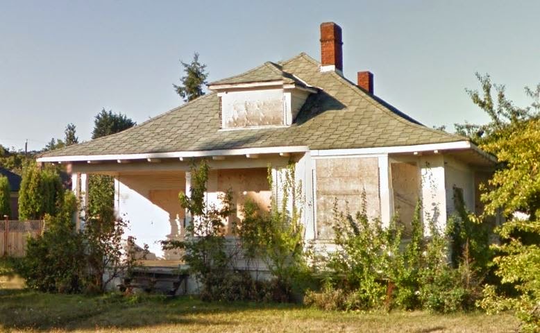
After coming across the link to the Google Maps street view of this house, I was curious about its current state, since the street view photo is from three years ago. So I biked by today, and instead of a house, there's just an empty lot. Since eventually Google will update their photos, I wanted to post some screenshots from the current street view so that there's still some record of the house out there. Couldn't find anything about it online, sadly, although I may have the wrong address since I'm just going by Google.
ETA 5/30/15: So I just found out that Google keeps their old street view images available, and you see them easily--just click the little clock next to the date when you're in street view mode. Since I published this post they've updated the street view pics to May 2014 (when I first posted, the current ones were from September 2011), but you can go back and see both the 2011 images (found in this post) and ones from 2009--super fascinating to me, because the house was in way better shape then, so it's cool to see what it looked like before this. Anyway, I'll leave this post up, and might still do posts about lost buildings occasionally, even if Google does have its own record of them.
ETA 8/5/15: Finally got around to adding a screenshot from 2009's Google Maps to this post--see below! I also found out some actual information on the house. I had the address wrong originally (2759 instead of 2750), which probably didn't help.
Anyway, according to this Facebook discussion, what went wrong was that "The owner attempted to lift the house to put in a basement. Basically he and a bunch of helpers began to jack it higher windows began to blow out and the house became unsafe. Friends live next door and watched and listened as the house was twisted apart."
Other people (in that discussion and another) were saying what a nice old house it was: "The fireplace had two faces in the two main adjacent entertaining rooms and [was] covered in an awesome royal blue tile which looked original with intricate metal work. It had side pillars denoting the dining area from the front lounge. The stairwell was quite grand. Farmhouse kitchen. And a tree growing partially inside the bathroom from the neglect." Someone who lived there in the 80s said it wasn't in the best shape even then.
Here's a photo from January 2008, with a little more info in the comments. All I have otherwise is that a Mrs. P McGill lived there in 1917--so obviously it was built before then.
Below, the rest of the 2011 screenshots from the original version of this post.
 |
| in context |
 |
| left side |
 |
| front again |
 |
| right side |
 |
| better view of the right side |
 |
| back |


